| |
Although
the 1953 floods are what we most remember, flooding
isn’t rare in this area. November 1887, January
1928 and February 1938 also saw Southwold’s
residents experiencing misery and inconvenience. (Click
on the 1938 photo immediately below.)
|
|
|
|
|
|
|
|
|
12th
February 1938 - The Wenhaston bus,
en-route to Southwold Ferry, is
caught by a high tide in Ferry Road
and becomes bogged down in mud and
gravel. P862
Click
picture to enlarge
|
|
|
|
|
|
|
|
|
|
|
|
|
|
On
9th November 2007 Southwold feared it
was about to happen again as an exceptional
'spring' tide was once more forecast to
coincide with a freak storm surge. In
the event, the coast received a spectacular
enough battering but fortunately tide
and
surge were separated by some hours and
we escaped total disaster.
Click here to see a
movie
of the 2007 surge, and click here
to read about North
Sea 'seiches' - the natural phenomenon
that makes our coastline so vulnerable
to tidal flooding. |
|
|
|
| |
|
|
|
A
RECORD OF THE 1953 FLOOD IN SOUTHWOLD |
| |
31st
January 1953 was a particularly dark day in
Southwold’s history. An unusually high
tide coincided with a deep depression of below
970 millibars and gale-force northerly winds.
All of which combined to send a tremendous surge
of water funnelling round from Scotland into
the North Sea. The result was one of the worst
floods in living memory along England’s
entire East Coast. It was a national disaster,
and 358 people died in all. Southwold did not
escape and lost five people to the flood. The
surge swept inland to the north and south of
the town, turning it into a virtual island for
two days and nights. |
|
|
| |
 |
|
|
|
| |
|
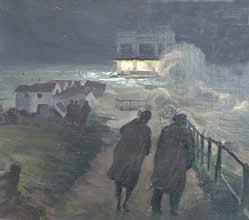
Southwold
sea front with its beach huts and pier pavilion,
is overwhelmed by the flood tide on January 31st
1953. Well known Southwold artist, Frank Forward,
witnessed this scene himself and started this
oil painting the same night. It hangs in the Museum. |
|
| |
|
|
|
|
|
|
The
Museum has a large collection of photographs
taken the day after the surge. Here is
a selection. Click on the pictures to
see enlarged versions and captions.
|
|
| |
|
|
|
|
|
|
|
|
|
|
|
|
|
|
|
|
|
|
|
|
|
|
|
|
|
Seiches,
Coriolis force and Amphidromic Circulation...
Prof.
Michael Rowan-Robinson explains the dynamics
of North Sea tides. Click
here
|
|
|
|
|
|
| |
LOOK
ON THE
BRIGHT SIDE!
None of these modern-day floods compares with
the iinundations at the end of the last Ice
Age. About 10,000 years ago, the area now covered
by the southern North Sea was a wide, marshy
plain. Within 500 years, rising sea levels meant
that about 50,000 square miles (13 million hectares)
disappeared beneath the waves. The North Sea
became linked with the English Channel about
8,500 years ago. |
|
|
| |
Click
the green headphone icons to hear extracts from
our Sound Archive |
|
| |

Harrold
Fisk remembers how it began.

Irene
Horwood watched the tea room float past.

John
Winter saw the ambulance man washed away.

William
Stannard recalls tragedy and rescue.

Southwold
as an island... "I don't want to see
that again."
- John Winter
|
|
|
|
|
|