| |
Navigating the Blyth
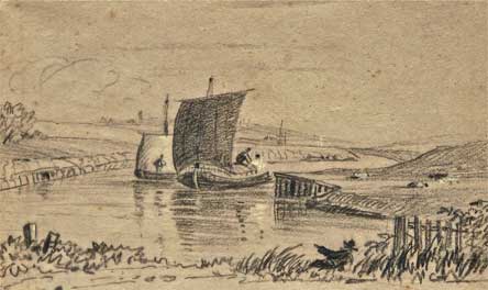
 A sketch (c 1820) by Henry Davy showing barges on the Blyth Navigation, looking downstream towards Southwold. Davy was born in Halesworth and lived in Southwold. He studied under the renowned East Anglian painter, John Sell Cotman

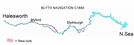
Simplified map of the Blyth Navigation derived from A T Clarke's Survey of 1821 and John R Wright's Survey of 1840. In addition to the re-channelling, shown in pink, a number of locks were created upstream as well as a tidal 'staunch' near Blyford to preserve water depth in the upper reaches during low tide. Many miles of new river 'wall' or embankment were built to allow saltings and marshlands to be reclaimed for patrure. For a more detailed version of the map please click on the image.
In 1759
work started on creating 'The Blyth Navigation'. This was a scheme to make the River Blyth navigable for cargo vessels from its estuary in Southwold to Halesworth. The river was embanked and straightened, locks and bridges constructed and the saltings reclaimed as productive grazing. Despite numerous problems and delays, the first barge-load of coal was carried upstream in the summer of 1761. Within a few years this became the cheapest and easiest route to transport cargo between the two towns. Heavy raw materials were shipped up-river to Halesworth, while agricultural produce was carried downstream to Southwold and thence, by sea-going vessels, along the coast. By the end of the 18th century the Blyth Navigation had transformed the economies of both towns and carried most of the commercial traffic between them until the arrival of the Southwold Railway in 1879. All the reclaimed land on both sides of the river has now reverted to tidal mudflats.
Coming
across on the Ferry
The
first reference to a ferry across the
River Blyth between Southwold and Walberswick
is in 1236. Margery de Cressy, Lady of
the Manor of Blythburgh and Walberswick,
was instructed to keep a ferry on her
side of the river. By the 19th century
the ferry franchise and the income from
it were in the hands of the Blois family
of Yoxford, who leased it to an operator.
An early ferry man was a Mr Todd of Walberswick
who provided the service in a rowing boat
for many years.
By 1885 the lease had transferred to a
public company, the River Blythe (sic)
Ferry Co Ltd., which was formed with capital
of £500, who modernised the operation
by installing a manually operated, chain-driven
pontoon, which was reputed to have been
built at Blackshore. By 1889 enough people
were using it to justify the company fitting
a steam-driven engine to the pontoon at
a cost of £111. In 1927 an even
larger steam-driven pontoon was introduced.
These pontoons were capable of taking
vehicles and animals. The Museum has a
photograph of a circus, complete with
elephant, being transported across the
river and of a large chauffeur-driven
limousine also coming ashore. In 1942 it was
discontinued and it was beached on the
Walberswick side where it remained for
many years as a sad and derelict reminder
of more expansive days. It was finally
cut up for scrap. After the war the ferry
resumed but as a rowing boat which continues
today and with which the Cross family
have a long tradition.
Arriving
by Steamer
In response
to the growth in visitor numbers, in 1887,
the London, Woolwich and Clacton on Sea
Steamship Co. was formed to operate a
service between London and Ipswich. Ten
years later, in 1897, the name changed
to one which became much more familiar,
Belle Steamers Ltd. 
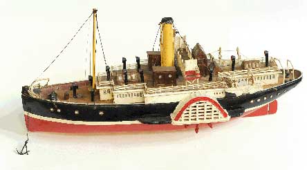
A model of a Belle paddle steamer To learn more about
Belle Steamers, click
here and to see a short movie of a
paddle steamer arriving at Southwold Pier,
click here
Use the links below
to explore the history of Southwold’s
other methods of transport:.
By
Road
By Rail
|